


February this year turned out to be so tender and carefree that mother atmosphere decided to fix its image a little. Therefore, after a long period of warm weather in Ukraine, the cold sets in.
The decrease in air temperature will be small, but noticeable. The wind direction will change from the south, south-east to west, north-west. Northern streams will bring cold at night to 1-5 degrees. In the northeastern part of Ukraine, namely in Sumy region, Kharkiv region, and Luhansk region, at the end of the week, thermometer scales will fall to -4 -10 degrees. Daytime air temperature will be still with “pluses” and will fluctuate within +1 +3 degrees.
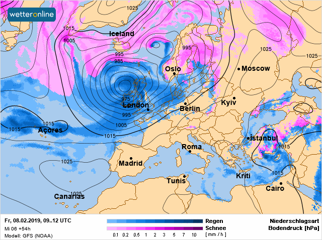
Source: www.wetteronline.de
Warm weather is expected in southern Ukraine, at night it is supposed to be near zero, in the daytime +4 +9 degrees, in Crimea +7 +12 degrees. There will be fogs in places, but cooling and changing the direction of the wind will reduce their scale.
Small frosts will help to strengthen the ice, to “dry” the road and air. The atmospheric front, which came from the north-west of Europe, on February 7, will determine sleet and rain in the east and in the central part of Ukraine. In the rest of the territory, significant precipitation is unlikely.
On February 8, the next atmospheric front from Poland will bring rain and sleet in the western regions of Ukraine. On February 9 and at night on February 10, precipitation is expected in the western part, in the north, and in the central regions. The southern part will be cloudy or partly cloudy, with no significant precipitation. The day of February 10th will also be dry in a large part of the territory of Ukraine.
The beginning of the next week will be marked by another warming. On February 11-12, the night air temperature will still remain among the minor “minuses”, but already in the daytime, the temperature is expected to gradually increase to +3 +7 degrees, in the south and in the western regions to +5 +11 degrees. On Monday, dry weather will reign everywhere, it will rain only in the west, and on February 12, precipitation will spread to most of the territory of Ukraine.
On February 13-14 the next change of air mass will take place in Ukraine – it will become colder by 2-6 degrees. Precipitations are expected in the form of sleet. Such a synoptic “swing” can adversely affect the health of people with heart and blood pressure problems.
In Kyiv, the second half of this week will be fresh, at night there will be slight frosts, 1-5 degrees below zero, in the daytime the thermometer scales will fluctuate around zero or within small “pluses”. On February 8th it will be dry in the capital, on February 9th it will snow, on February 10th, precipitation will stop. During February 11th-12th, it will warm up to +2 +6 degrees, on February 13th-14th, it will become colder by 2-4 degrees again. On Monday it will be dry in Kyiv, in the future, wet weather, rain or sleet will prevail, depending on the air temperature.
If we could give ourselves the names of the months now, then this February should obviously be renamed – for kind of February it is, with air temperatures of +10 degrees, icicles, merry puddles and remnants of darkened snow on the sidewalks? But it is not a secret that often people don’t fit their names, appointments, positions, or status.
At least February is always in its place and always conscientiously carries out its main mission – ending the winter and giving way to spring.
Natalka Didenko